For nearly 50 years, NatureServe has been developing standard methods for collecting and tracking the status of imperiled species and ecological systems, and tools that embody these methods. NatureServe’s data management systems have resulted in the most standardized set of biodiversity data in North America.

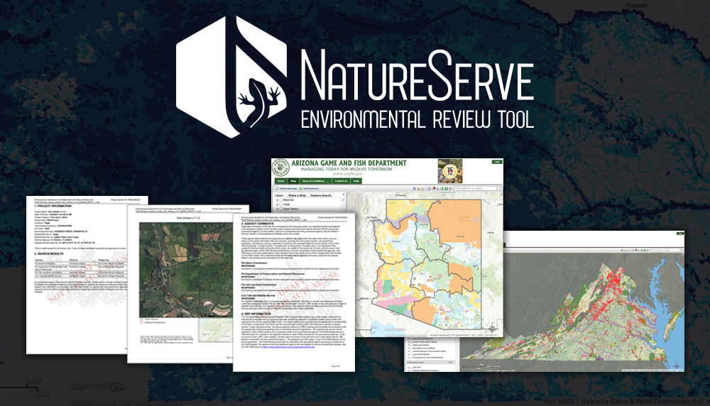
Environmental Review Tool
Interactive access to natural resources data. The tool can be highly customized to match the needs of the hosting agency and is currently successfully deployed for more than 12 states with further deployments in development.
Value
The Environmental Review Tool represents a highly customizable off-the-shelf web application framework. By leveraging and extending this robust platform, NatureServe can implement and deploy a custom tool for an agency for a fraction of the cost of building a new, made-to-order system. Using a software-as-a-service delivery model, ERT clients are ensured ongoing system improvements, support, and secure hosting for an affordable annual fee.
Learn more about the tool through this interactive story map.
Features & Benefits
The Environmental Review Tool represents a highly customizable off-the-shelf web application framework. By leveraging and extending this robust platform, NatureServe can implement and deploy a custom tool for an agency for a fraction of the cost of building a new, made-to-order system. Using a software-as-a-service delivery model, ERT clients are ensured ongoing system improvements, support, and secure hosting for an affordable annual fee.
Learn More
Additional Resources
Clients
- Arizona Game & Fish Department
- Colorado's Conservation Data Explorer
- Kansas Department of Wildlife and Parks
- Louisiana Department of Wildlife & Fisheries
- Minnesota Department of Natural Resources
- Missouri Department of Conservation
- Nebraska Game and Parks Commission
- Natural Heritage New Mexico
- North Carolina Department of Environment & Natural Resources
- Pennsylvania Conservation Explorer
- Pennsylvania Conservation Opportunity Area Tool
- South Dakota Game, Fish and Parks
- Tennessee Department of Environment and Conservation
- Virginia Department of Conservation & Recreation
Contact
Lori Scott
CIO and VP for Technology & Partnerships
Email
(703) 908-1877

Biodiversity Dashboards
Dashboards are interactive tools that visualize the health and trends of biodiversity and track conservation performance at regional, national, basin, and site scales. The dashboards monitor the status of key biodiversity indicators for any part of the world, signaling both where and what conservation action is needed.
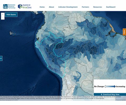
The BIP Dashboard
Developed together with the Biodiversity Indicators Partnership (BIP) and UNEP-WCMC, the BIP Dashboard harnesses NatureServe's strengths in information technology and data visualization to allow exploration of progress in achieving the Aichi Biodiversity Targets of the Strategic Plan for Biodiversity 2011-2020.
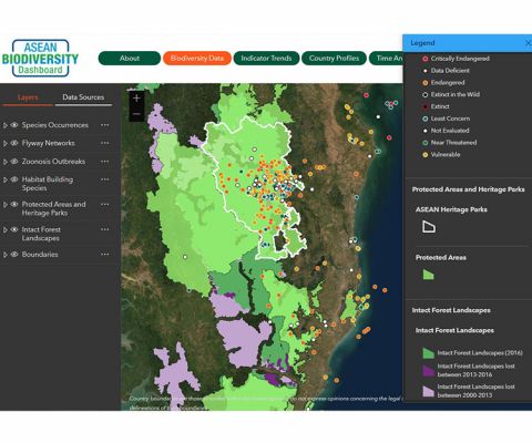
The ASEAN Biodiversity Dashboard
In partnership with the Association of Southeast Asian Nations (ASEAN), NatureServe created the ASEAN Biodiversity Indicators Dashboard, an interactive online resource that converts multiple complex datasets into the indicators most useful to decision-makers across this region, where millions of people’s livelihoods depend on the area’s rich but highly threatened biodiversity.

iMapInvasives
Invasive species pose a significant and growing threat to native biodiversity. They compete with native species for resources and often have no native predators to keep their numbers in check. Any large scale effort to protect biodiversity and the environment must be able to deal with the effects of invasive species. Early detection is often the key to successful eradication.
iMapInvasives is a cloud-based application for tracking and managing invasive species. Developed by NatureServe and partners in the iMapInvasives Network, it gives resource managers the power to know about the latest observations of an invasive species, in real time, so they can respond to new threats to the ecosystems they manage. With the newest release, iMapInvasives will share information with other invasive species mapping platforms, empowering decision-making at county, state, national, and international levels. Its tools assist citizen scientists and natural resource managers working to protect natural resources from the threat of invasive species.