The NatureServe Network consists of 60+ programs and over 1,000 conservation professionals across the U.S. and Canada. Together, we provide best available, decision-quality, objective, and credible data on North American species and ecosystems.
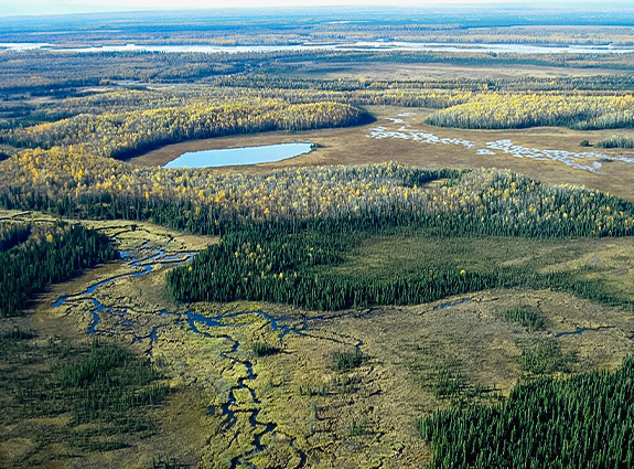
The NatureServe Network uses standard methods and tools for collecting and mapping data on imperiled species and ecosystems and for assessing the conservation status of species and ecosystems. Our Biodiversity Location Data includes one million documented locations for over 100,000 plants, animals, and ecosystems occurring across the U.S. and Canada.
Explorer
Explorer Pro
Public Data Access
Species and ecosystem profiles, including information on conservation status, distribution, trends, and more
Search by taxonomic group, conservation status, or state/province
View or export tabular data
No access restrictions
Public Data Access
(Registered Users)
Explore species distribution data in an online map viewer
View public-scale documented species locations and range maps
Link to species profiles
Filter and view data on the map; search by species or area
Generate and export site-specific reports
Register and agree to Data Use Terms
Licensed Data Access
Explore high-resolution species distribution data in online map viewer
View high-resolution documented locations, species habitat models, and range-maps
Link to species profiles
Filter and view data on the map; search by species or area
Generate and export site-specific reports
Download or stream spatial data for use in local GIS
Sign License Agreement and take Data Use Training
Explorer Pro Pricing
Details of Data Provided by NatureServe
Geographic Scope
NatureServe's Biodiversity Location Data products include documented distribution data (Element Occurrences and Observations) and modeled distribution data (Species Habitat Models) for the U.S. and Canada. Descriptions of each are provided below. If you are interested in data within a single state or province, contact your local NatureServe Network program.

Biodiversity Scope
Our data focus on species of conservation interest, including those assessed by NatureServe and our Network as globally vulnerable (G3, imperiled (G2), or critically imperiled (G1) or with a state or provincial conservation status of vulnerable, imperiled, or critically imperiled (S1-S3). We also maintain data for species with a federal status under the U.S. Endangered Species Act and Canadian Species at Risk Act and for species with a subnational protection status under state, provincial, territorial, or tribal laws. In many localities, we can also provide documented locations of ecosystem occurrences of conservation interest.
To better understand NatureServe Data, as well as additional data offerings for North American ecosystems , check out our Mapping Biodiversity page and watch our Data Use Training videos. Contact us for more information.
Documented Distribution Data
Our documented location data include two standard data types: Element Occurrences and Observations. Element Occurrences are mapped areas that, if conserved, can contribute to the long-term persistence of at-risk species. They are mapped using a consistent national methodology and include attribute information about the condition or status of each location. Observations represent places where a species has been observed, though not all observations are places that contribute to the long-term persistence of a species. Both Element Occurrences and Observations are taxonomically verified by trained biologists and vetted by our Network. See our Element Occurrence Standard and Observation Data Standard for more information.

Modeled Distribution Data
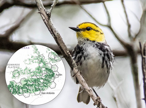
Species Habitat Models identify areas where environmental conditions favor the occurrence of a species within its range. They complement documented distribution data by providing information on whether species are likely to occur in areas that have not been comprehensively surveyed. NatureServe maintains a library of over 1,000 habitat models for species of conservation interest. Methods for developing species habitat models may be inductive (using documented species occurrence data, environmental covariates, and statistical methods to predict suitability) or deductive (using expert knowledge to map areas of likely occurrences based on environmental data). We work closely with our Network Programs and other species experts to vet model outputs and refine each model to arrive at an optimal prediction. Models include extensive descriptive information, including details on the environmental factors driving the prediction and an assessment of model confidence (i.e. how well the model performs in capturing actual habitat) to guide users in appropriate applications. See our Species Habitat Modeling Standard for more information.
Services Included with NatureServe Data License
- Data Permissions: NatureServe Network Programs are the primary source of spatially explicit data, and require permission or notification before data can be provided to an external party. NatureServe will secure the required data-sharing permissions from all participating U.S. and Canadian Network Programs for each external request of spatial data.
- Data License Agreement: Based on input from a data requester regarding the use of data and our Network Programs, NatureServe will craft a data license agreement that outlines the terms by which the Licensed Dataset can be used. Generally, NatureServe license agreements allow unlimited use of the Licensed Dataset internally for conservation purposes and limited use of generalized data externally. Some species that are very sensitive to collection or disturbance or species locations occurring on private lands may be excluded or generalized.
- Data Integration and Standardization:
- Taxonomic: NatureServe Network Programs follow valid but varying taxonomic and nomenclatural sources resulting in different names being used for the same taxa or the same name for different taxa. NatureServe scientists reconcile these differences, resulting in a fully integrated and cohesive dataset.
- Non-standard data: Most NatureServe Network Programs use NatureServe's proprietary biodiversity data management system (Biotics) and participate in an annual exchange of information that supports standardized data across jurisdictional boundaries. A few Network Programs use a non-standard system. NatureServe will integrate all of these non-standard datasets, resulting in the delivery of one standardized data product that is comparable across jurisdictional boundaries.
- Format of Data: NatureServe spatial data is primarily provided in the Explorer Pro interface to ensure access to current data, but data can be provided as GIS layers, Geodatabases, or other formats as requested.
- Metadata: NatureServe will provide all metadata needed to use and interpret the NatureServe Licensed Dataset. Metadata will be provided in a format discussed and agreed to with a data requestor and can include FGDC-compliant metadata.
- Technical support: NatureServe will provide ongoing support in the use and interpretation of the Licensed Dataset for the term of the license, which is typically 12 months.
Biodiversity Location Data Use Terms
NatureServe data is sensitive and proprietary, and the license fees applied are critical to maintaining the data over time. When species locations are precise, the data can only be used internally for conservation purposes by a licensee with limited use of generalized data externally. When NatureServe data are generalized, they can be used more freely but require a citation and are prohibited from being redistributed for commercial purposes. A sample of our data licensing terms can be found here.
Additional Services Offered by NatureServe
- Custom data requests
- Species habitat model development
- Biodiversity metrics / indicator development
- Identification of conservation priority areas
- Climate change vulnerability assessments
- Ecosystem mapping and ecological integrity assessments
Looking for something specific?
Contact us!
Not quite finding what you want in our standard online data products? NatureServe can provide custom datasets and analyses designed to meet your specific needs.
NatureServe can provide both non-spatial and spatially explicit information for species and ecosystems either regionally or nationally. We can provide data products in a variety of formats from simple Excel spreadsheets, map images, or GIS layers, to more complex relational Access databases, Geodatabases, or custom Map Services. For data within a single state or province, contact your local NatureServe Network program.
To submit a custom data request, please contact us at datasupport@natureserve.org or click the button below.