This map represents the development of a multi-level classification of vegetation types across Africa that are suitable for use in conservation planning. Classifying and mapping terrestrial ecosystems across the entire continent of Africa will stimulate critical scientific collaborations to put in place basic information on the location, status, and trends in condition, and provide a foundation for conservation action. It will also ensure that consistent and usable information for ecosystem assessment is maintained into the future.
This continent wide mapping project was a joint venture between USGS, NatureServe, and The Nature Conservancy to delineate meso-scale (10s to 1000s of hectares) terrestrial ecosystem units; defined here as the macrogroup scale of the International Vegetation Classification (IVC) hierarchy. We developed classification concepts at IVC Class, Subclass, Formation (approx. WWF major habitat types), Division, and Macrogroup scales. The biophysical spatial distributions of IVC macrogroups were developed using Classification and Regression Tree methods and tools. Model parameters include training data from expert derived sample points and existing local map data (n=24,366 continent) and Madagascar (n=5388) . Independent data were based upon both standard geophysical (e.g., slope, aspect, elevation, lithology) easily derived (e.g., bioclimate, thermotypes, ombrotypes, phytogeographic regions) datasets. All models used a spatial resolution of 90m.
The NatureServe component of the project described here is a valuable resource to conservation planners and regional ecologists because regionally accepted terrestrial vegetation names and concepts were applied to the unique combinations of biophysical data. These concepts and maps will greatly facilitate definition and mapping of more localized terrestrial ecosystem units in subsequent projects. This project brought together NatureServe, TNC and key global institutions (e.g., USGS, GEO, FAO), Global Conservation Organizations (WWF, WCS, CI), African Conservation Organizations and institutions, and expert ecologists from across the globe.
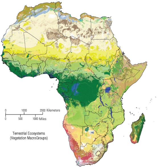
This project resulted in the first continent-wide classification and map of vegetation units using the hierarchical structure of the International Vegetation Classification. Prior continental efforts in Africa used qualitative characterization of major vegetation formations and ecoregions. Here, for the first time, a cross-section of African vegetation experts collaborated to define units within the each of the five higher levels of the IVC hierarchy, and then gathered sample location data for over 130 units at the 5th classification level of macrogroup. These sample data, derived from expert data sets and local high-quality map products provided a foundation for a spatial model of the potential distribution of each type. Using newly available map inputs on bioclimate, landform, surficial geology, and drainage, inductive modeling tools were applied to generate this map product. This collaboratively developed classification and map information is a great value for multi-jurisdictional conservation planning in typically biodiversity rich - but data-poor - ecoregions; of which Africa has many. It also sets the stage for subsequent mapping efforts at finer thematic and spatial resolution.
This map provides a baseline for ecological conditions for the region that can be used for conservation planning, resource management and in the future to assess changes in ecosystem status and evalute trends.