Climate change puts stress on natural ecosystems. As that stress increases, it interacts with other common ecological stressors, like invasive species, habitat loss, and fragmentation. It also affects dynamic processes like natural disturbances from wildfires or annual flooding along streams and shorelines. We need tools to help us understand the type and severity of these interacting ecosystem stressors so that we can respond and minimize the loss of biodiversity.
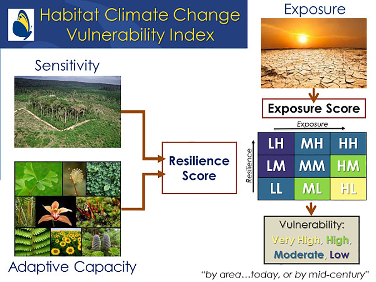
The Habitat Climate Change Vulnerability Index (HCCVI) is a framework for a series of measurements to determine how vulnerable a given natural community or habitat type might be to climate change. We use available data and expert knowledge to evaluate relative climate change exposure (ecological stress caused by climate change), and resilience (the ability to cope with ecological stress and avoid collapse). This framework serves as a habitat-based companion to the NatureServe Climate Change Vulnerability Index for species.
The HCCVI aims to implement a series of measures addressing climate change exposure and ecological resilience for each community type as it varies across its distribution. Since quantitative estimates may not be feasible for all measures, both numerical index scores and qualitative expert categorizations may be used. Index measures are organized within categories of Exposure, and Resilience, with Resilience further broken down into Sensitivity and Adaptive Capacity. The combined relative scores for exposure and resilience determine the categorical estimate of climate change vulnerability for a given period (e.g., 50 years into the future).
Climate Change Exposure – This includes climate change stress and its likely effects on ecosystem-specific processes. These analyses include the identification of baseline climate conditions, including historical climatic variability, and future climate projections, including their departure from historical conditions. Where possible, changing climate variables are connected to dynamic processes, such as wildfire, hydrology, and sea level rise effects.
Climate Change Resilience – This includes the capacity of a system to absorb disturbance and reorganize while undergoing change to still retain essentially the same function, structure, identity, and feedback. For the HCCVI framework, we have broken measures into two categories: Sensitivity and Adaptive Capacity.
Sensitivity – This includes human alterations affecting ecological resilience. Analyses consider alterations to natural patterns and processes, such as landscape fragmentation, effects of invasive species, or human alterations to dynamic processes. These human alterations are considered here independently of climate change but likely interact with changing climate. These analyses could also include a temporal dimension, considering both legacies of past land use along with current or predicted future conditions.
Adaptive Capacity – This includes natural characteristics that affect the potential for resilience in a changing climate. Analyses consider aspects of natural species composition, such as the relative diversity within groups of species that provide critical functional roles (like nitrogen-fixing species), or the relative vulnerabilities of individual species that provide “keystone” functions (“ecological engineers” like prairie dog or beaver). They also consider natural variability in microclimate or geophysical diversity and how that varies across the distribution of a given natural community type.
Western Landscapes Managed by the Bureau of Land Management
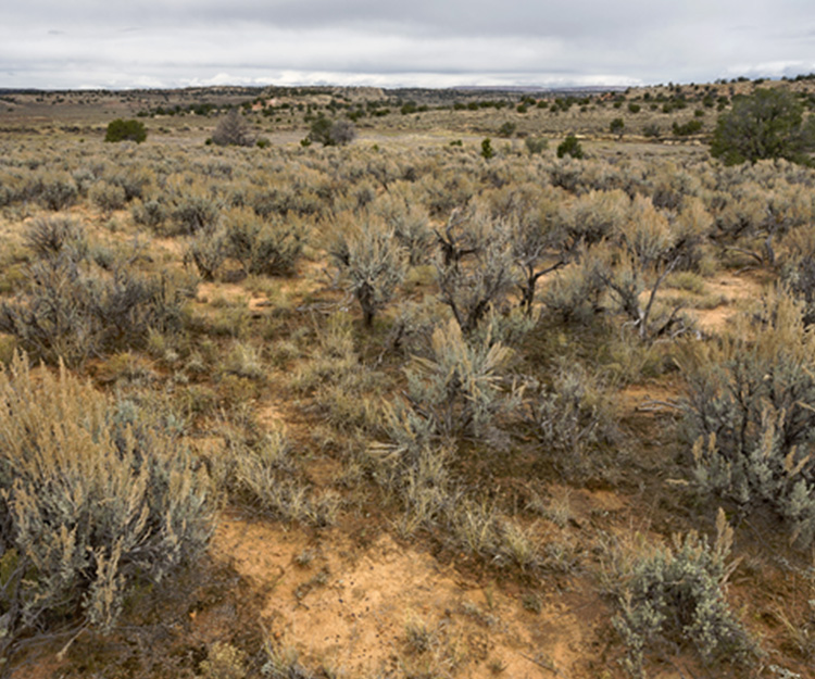
Inter-Mountain Basins Big Sagebrush Shrubland occurs throughout much of the western U.S., typically in broad basins between mountain ranges, plains, and foothills between 800 and 2500 m elevation. Soils are typically deep, well-drained and non-saline. These shrublands are dominated by basin big sagebrush and Wyoming big sagebrush, with grasses like bluebunch wheatgrass, Indian ricegrass, blue grama, Idaho fescue, or needle and thread grass. In these landscapes, temperatures fluctuate widely each day, and across seasons, and much of annual precipitation falls as snow, with frequent growing-season drought.
Ecological interactions of climate, herbivory, and wildfire result in complex patterns of vegetation structure and species composition. Increasing fire frequency and severity can eliminate shrubs from the stands, as big sagebrush does not sprout after fire. Conversely, in the complete absence of fire, deep-rooted shrubs can shade out native grasses. At higher-elevation sites with less frequent wildfires, conifers trees and shrubs like pines and junipers may invade and eventually displace sagebrush.
Over time, these shrublands have been converted for agriculture in some areas, but for the most part, livestock grazing has been the common land use and fragmentation by rural road networks is common. Overgrazing has often resulted in the loss of native bunchgrasses and has been accompanied by wildfire suppression. The introduction of invasive annual grasses has resulted in large and frequent fires that support their further expansion. Vast areas of these shrublands have been severely altered by the introduction of invasive cheatgrass.
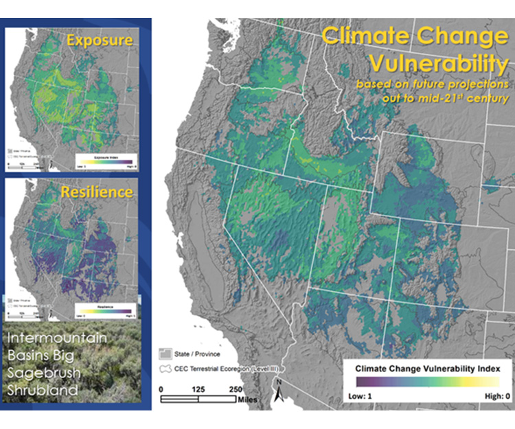
Applying the HCCVI to these shrublands includes the use of maps and expert analysis for climate exposure, and resilience.
Climate Exposure measures used 30-year averages of 19 common temperature and precipitation variables projected to the mid-21st century and compared them against their averages measured during the mid-20th century. This resulted in a relative exposure map highlighting areas of greatest expected climate stress to these shrublands in the Central Great Basin, Snake River Plain, and Colorado Plateau. A warming climate with more frequent droughts weakens big sagebrush shrubs and eliminates recruitment. Additionally, warmer/drier fuels may result in more frequent fires that could increase the rate of loss of mature stands through the conversion of these shrublands to annual grasslands that are adapted to frequent fire.
Resilience measures included those for Sensitivity, encompassing landscape fragmentation, invasive plant species abundance, and alteration to natural wildfire patterns. Maps of these factors indicate locations throughout the West where the current conditions of these shrublands are impacted by prior land uses, contributing moderate-high scores for Sensitivity. Adaptive Capacity measures included evaluation of different functional species groups (soil crusts, nitrogen-fixing plants, seed dispersers) and these vary from high in some and low in others. Microclimate and geodiversity are moderate, as this type occurs in a broad range of topographic settings.
Looking out to the 2040-2070 timeframe, overall vulnerability for this shrubland type varies from low in some places to moderate and high in others. Driven both by measures of climate change exposure and sensitivity, moderate to high climate change vulnerability is anticipated for several large ecoregions, including the Snake River Plain, the western and eastern portions of the Central Basin and Range, and the eastern Columbia Basin.
Applying this Knowledge to Vegetation Management across the West
Land managers can use the results of this analysis to evaluate big sagebrush shrublands within their management jurisdiction and make better decisions for adaptive vegetation management. Near-term, most will be well suited to maintain high-quality ecological conditions by minimizing surface disturbance that could lead to the expansion of invasive annual grasses. Restoration practices can target invasive plant species and recover natural wildfire frequencies. Monitoring management success and changes in species composition (plants, birds, insects, etc.) will be increasingly important to inform conservation decisions.
However, one common form of vegetation management in this region involves the removal of juniper trees that have been expanding their distribution into adjacent sagebrush shrublands. This vegetation change has resulted from intensive grazing and suppression of wildfire in these landscapes. Our climate change analysis indicates where the changing climate may also have been driving this expansion.
The map from Nevada below shows a pink color where the climate that characterizes pinyon and juniper vegetation expands at the expense of adjacent sagebrush habitats. This means that changing climate – in this case, from increasing summer precipitation - may well be interacting with the other historical land uses to drive this change on the landscape. In some cases, managers may have been expending a lot of effort and resources to work “against the tide” being driven by recent climate change.
Interestingly, when we look at climate projections for this same vegetation into later decades of this century we see that increasing temperatures may well reverse this trend, and perhaps bring a halt to the expansion of juniper trees into sagebrush in this area.
So the HCCVI may help land managers to better adapt to changing conditions and make good decisions about vegetation management to benefit both biodiversity and rural economies.
For additional background and detail see this publication: Land 2019, 8, 108; doi:10.3390/land8070108
In 2019, NatureServe completed an assessment of 52 major vegetation types in the Western United States. You can read the report and explore the data through an interactive map viewer by following the links below, and find more information at the links below.
BLM PROJECT SITE
READ THE REPORT
DATA FOR THE CURRENT TIME PERIOD (AS OF 2014)
DATA FOR THE FUTURE TIME PERIOD (2040-2070)
Learn More
Additional Resources
- Habitat Climate Change Vulnerability Index Applied to Major Vegetation Types of the Western Interior United States
- Assessing Vulnerability and Resilience of Major Vegetation Types of the Western Interior U.S. Forests & Woodlands
- Assessing Vulnerability and Resilience of Major Vegetation Types of the Western Interior U.S. Shrublands & Grasslands
Related Projects
Related Publications
- Climate Change Vulnerability and Adaptation Strategies for Natural Communities: Piloting methods in the Mojave and Sonoran deserts
- Manager’s Guide to Refuge Vulnerability Assessment and Alternatives: Overview and Practical Considerations
- Refuge Vulnerability Assessment and Alternatives Technical Guide: Assessing Vulnerability for Refuges and Landscapes and Developing Alternatives for Management
- Habitat Climate Change Vulnerability Index Applied to Major Vegetation Types of the Western Interior United States
- Modeling Invasive Annual Grass Abundance in the Cold Desert Ecoregions of the Interior Western United States
Client
Contacts
- Patrick McIntyre
Director of Ecology
patrick_mcintyre@natureserve.org
(703) 797-4812