NatureServe Canada’s Ecosystem-based automated range maps (EBAR) initiative is developing publicly accessible range maps for priority species.
EBAR Range Mapping Project Overview
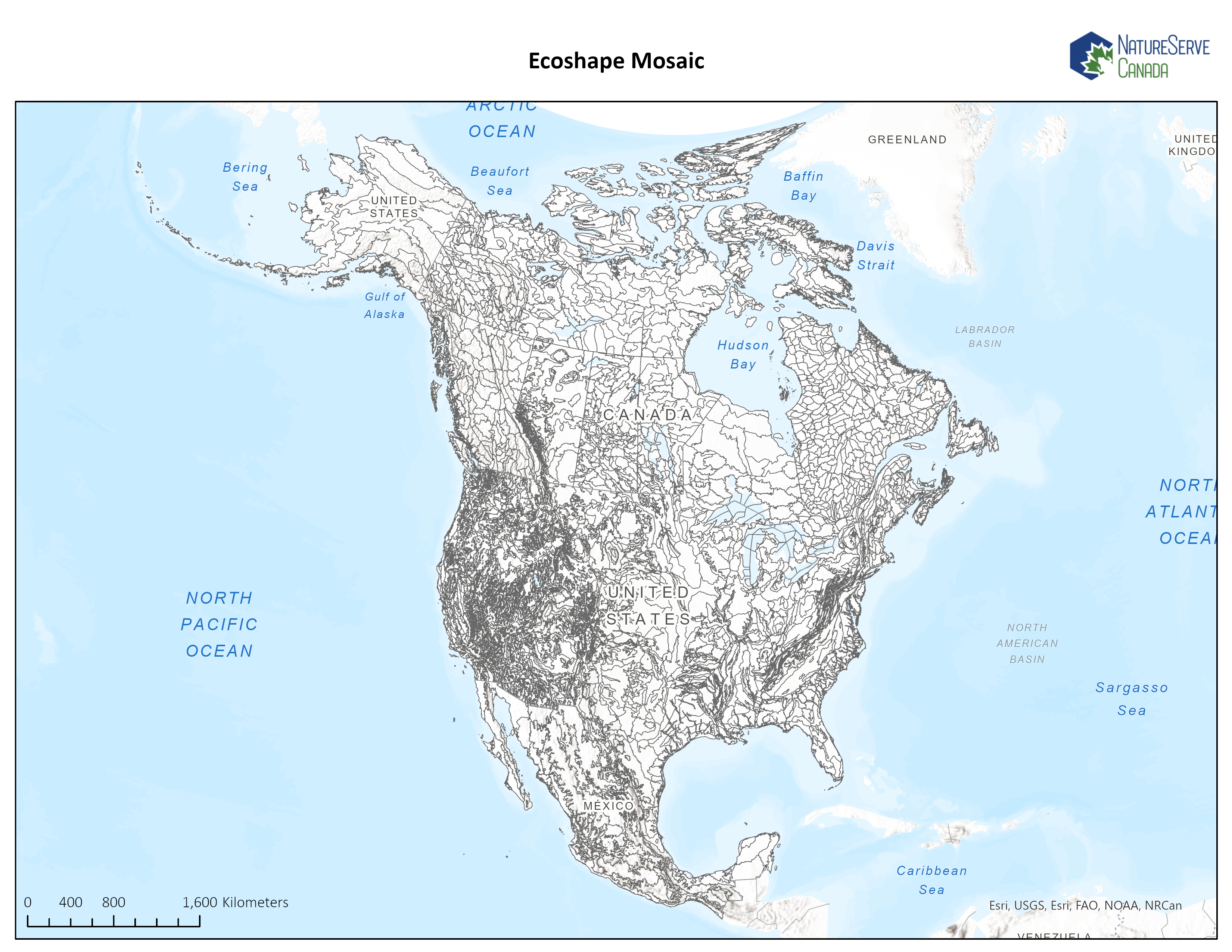
EBAR maps combine biodiversity data with expert knowledge to populate ecoshapes (which are ecoregions, ecodistricts or similar ecological land classifications) with species presence information. Each ecoshape is associated with a set of references for the species information providing transparency regarding the underlying data.
NatureServe Canada EBAR maps support priority programs such as environmental impact assessments, status assessments by the Committee on the Status of Endangered Wildlife in Canada (COSEWIC), Species At Risk Act recovery action plans, the identification of Key Biodiversity Areas (KBAs) and provincial and territorial Species at Risk programs and legislation.
The objectives of the project are to develop national range maps that:
- Incorporate the best available species occurrence information.
- Can be reviewed and refined by species experts in an ongoing and efficient manner.
- Provide access to reference information of the underlying occurrence data.
- Are publicly available at no charge.
- Are provided in an electronic format that permits efficient customization and integration by biodiversity experts, organizations and decision-makers.
Project Updates March 2026
280 = number of data providers
52 million = number of species observation data points collected from these data providers
560,000+ = number of Element Occurrences collected from NatureServe Canada Conservation Data Centres
2,200+ = EBAR maps auto-generated to date
910+ = EBAR maps that have been fully expert reviewed
290 = number of experts who have contributed their time to review
810+ = EBAR range maps published on the EBAR website (see downloads below)
650+ = EBAR auto-generated ranges in need of expert review
68,000+ = downloads via this webpage (PDF, GIS data packages) by industry, government and non-profit sectors
The EBAR project is scheduled to conclude March 31, 2026 due to funding constraints. If your organization is interested in supporting future EBAR mapping focused on your priority species, please reach out to us at EBAR-KBA@natureserve.ca as soon as possible.
THANK YOU to all expert reviewers and data providers for contributing to this national project!
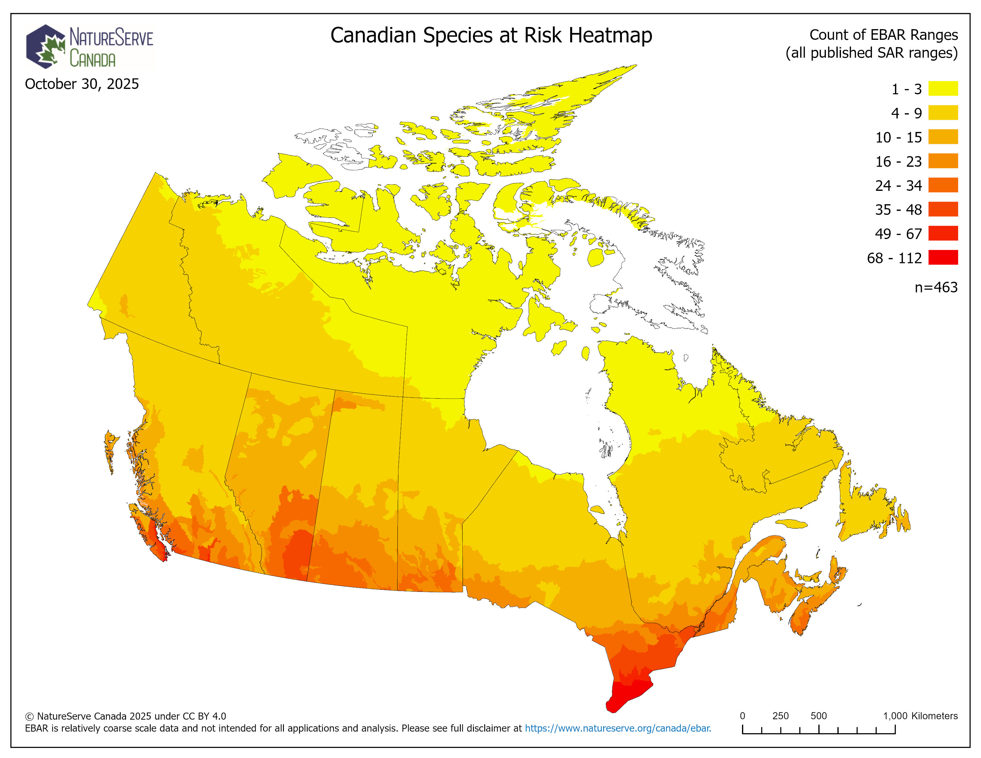
EBAR Heatmap
The NatureServe Canada EBAR-KBA team created a Heatmap that shows how many EBAR species ranges (from the published ranges of SARA-listed species) overlap with each Ecoshape. The map creation date and the number of ranges used in the analysis can be found on the map jpeg and in the GIS data package (see additional details below).
Ecoshapes with a darker red coloration indicate areas with a higher count of EBAR ranges that intersect the Ecoshape (i.e., higher count of species known to be present, historically present, or expected to be present within the Ecoshape).
For a full list of species included in this Heatmap analysis, please see: https://gis.natureserve.ca/download/EBARHeatmapPublishedSAR.csv
Fill out the Download Form below to access the EBAR Heatmapping documentation, PDF and JPEG maps, and GIS data package.
NatureServe Canada will update the Heatmap on a semi-regular basis. Please check back in for updates.
To access the interactive web map on ArcGIS online, please click here.
EBAR Workflow
Species “Data Mining”
Accurate range maps require the best available species data. EBAR maps incorporate species occurrence information from NatureServe Canada and NatureServe Network Conservation Data Centres, provincial, territorial and federal governments, citizen science platforms and digital biodiversity data resources (e.g., NatureCounts, GBIF, iNaturalist), academia, non-governmental organizations, industry, species experts and Traditional Ecological Knowledge (TEK).
To access the full list of datasets compiled for the EBAR database and their corresponding sources/references, please click HERE.
We are currently focused on data mining and EBAR mapping for:
- Species that are priorities for status assessments by the Committee on the Status of Endangered Wildlife in Canada (COSEWIC) and Species At Risk Act recovery action plans.
- Priority species for the Canada Key Biodiversity Areas program (i.e., KBA Trigger Species)
- Additional priorities for Environment and Climate Change Canada, including migratory birds and COSEWIC candidate species.
To access the list of priority species, please click HERE.
If you are aware of data sources for these species please contact us at: EBAR-KBA@natureserve.ca, or complete this SURVEY.
Data Management
Project data is stored on a secure Canadian cloud-based Microsoft Azure server. An ArcGIS Enterprise Server manages access to the EBAR database, facilitates data analysis using a variety of tools, and provides the foundation for the EBAR Reviewer online tool.
“Automated” Range Map Generation
The next step in EBAR project workflow is to populate the ecoshapes mosaic (i.e., ecoregions, ecodistricts or similar ecological land classifications) with species presence information (e.g., present, presence expected, historical) using the mined data. Repeatable GIS-based routines (e.g., python scripts) are employed to facilitate and automate this process as much as possible.
Expert Review
Expert review is critical to fill in data gaps of the “automated” EBAR maps, particularly for lesser known and rare species. Scientific, traditional and other expert knowledge holders are recruited to review/refine the “auto-generated” EBAR maps based on additional data they may have and/or their on-the-ground knowledge. The EBAR Reviewer online app allows experts to engage in this process in an efficient and secure manner.
Detailed instructions can be accessed in the EBAR Reviewer training manual that is provided to expert reviewers.
There is also an EBAR Reviewer Training Video to assist reviewers with navigating the EBAR Reviewer Application and provide instructions for conducting reviews.
If you are interested in participating as an expert reviewer please contact us at: EBAR-KBA@natureserve.ca, or complete this SURVEY to provide information on additional data sources for EBAR priority species and/or your availability for expert review to improve our EBAR range maps.
Data Publishing
NatureServe Canada makes EBAR maps publicly available online at no cost. Species ranges are available in PDF format or as a geospatial data package with associated metadata (which facilitate customization and integration into standard GIS tools). EBAR species ranges are available for download from this webpage, through NatureServe Explorer 2.0 (under the Distribution section), our Esri online app and the Esri Living Atlas.
To learn more about NatureServe Canada’s EBAR Mapping Project please contact us at: EBAR-KBA@natureserve.ca.

EBAR Maps Downloads
Published EBAR maps can be found below. Ranges are available in PDF format or as a geospatial data package with associated metadata. We will continue to update the list of available EBAR maps as they are completed.
This section provides access to PDF and Geospatial Data Package files for NatureServe Canada Ecosystem-based Automated Ranges (EBAR). The list and links to the published range maps are provided further below.
EBAR map production methods are detailed in this document. The French language version of the methods document can be accessed here.
The long-term goal of NatureServe Canada is to offer a suite of spatial products, so that users can pick and choose information that works best for them depending on the intended uses, and life history of the species in question. Many programs in the NatureServe Network release finer scale Element Occurrence data, and we are working with a broad suite of partners to scope a collaborative project to produce finer-scale Suitable Habitat Models (SHMs) after the EBAR project is fully implemented.
EBAR species ranges will be published in batches as they are finalized. Please check this webpage regularly for new species ranges. EBAR species ranges are also available through NatureServe Explorer 2.0 (under the Distribution section), our Esri online app and Esri Living Atlas.
You can access the Python, R and JavaScript code used to develop EBAR and the EBAR Reviewer on GitHub.
Please note EBAR species ranges have not been reviewed and/or endorsed by all NatureServe Network Programs.
EBAR species ranges are free of charge and released under CC BY 4.0.
If you would like to use EBAR species ranges in a project or products, please use the following citations:
Multiple species:
NatureServe Canada. 2026. Ecosystem-based Automated Range (EBAR). Ottawa, Canada. Retrieved on [insert date] from [insert url]
Single species:
NatureServe Canada. 2026. Ecosystem-based Automated Range (EBAR) for [insert species name, version, stage, and scope]. Ottawa, Canada. Retrieved on [insert date] from [insert url]
We are seeking partners and funding to develop species ranges based on alternative base linework mosaics (e.g., marine or watershed polygons to produce ranges for aquatic species).
For questions, feedback, technical support, or to discuss project opportunities please contact the NatureServe Canada EBAR team at EBAR-KBA@natureserve.ca.
When using EBAR it is important to remember that range data:
- Represent the geographic extent where a species may occur
- Are relatively coarse scale
- Are appropriate for screening and education purposes, but are not intended for all types of applications and analyses
- Will represent the distribution of some species better than others
- The absence of data in any geographic areas does not necessarily mean that a species is not present
- An ecoshape with a presence value does not necessarily mean that a species is present throughout the entire geographic area
EBAR species ranges are produced at different geographic scales defined in the Range Scope:
- Canadian: only includes ecoshapes for the species in Canada, although it is known to occur outside of Canada
- North American: only includes ecoshapes for the species in North America (Canada, the US and Mexico), although it is known to occur outside of North America (e.g., Europe or Asia)
- Global: includes all the known ecoshapes for the species in the world
EBAR species ranges have different levels of review. Please only use the categories appropriate for your application or analysis. Only Expert Reviewed species ranges are available as geospatial data packages and through NatureServe Explorer 2.0, Esri online app and Esri Living Atlas. Please contact the EBAR team if you would like access to geospatial data for Low Star Rating, Partially Reviewed or Insufficient Data species ranges.
- Expert Reviewed: this species range category was expert reviewed and provided a star rating of 4 or 5 indicating the range accurately reflects the known range of the species in the range scope.
- Low Star Rating: this species range category was expert reviewed and provided a star rating below 4 indicating the range does not accurately reflect the known range of the species in the range scope. Please contact the EBAR team if you have additional data for these species.
- Partially Reviewed: this species range category was only expert reviewed for a portion of its known distribution. The jurisdictions reviewed are listed in the metadata. Please contact the EBAR team if you are interested in reviewing the species range through our online app.
- Insufficient Data: this species range category was expert reviewed and indicated that there is not enough data available to create an accurate range (e.g., the range is based on a single type specimen, or additional surveys are needed). Please contact the EBAR team if you have additional data for these species.
Fill out the form below to get started. After submitting, you will be redirected to the download page.