The multi-agency LANDFIRE effort maintains a series of national data sets in the United States related to natural vegetation and wildland fire. Updated map information is being released in 2020 and 2021 (download link). LANDFIRE data are used in natural resource assessment, planning, management and monitoring. Prior to LANDFIRE, efforts to support decisions for managing wildland fire were made locally. That meant that most decisions were tactical; i.e., how best to fight a wildfire. Strategic approaches to managing wildland fire proactively target resources towards land use and vegetation management that will minimize uncontrollable wildland fire. Funded under with the National Fire Plan, LANDFIRE was established to make coordinated investments in information, most efficiently developed at the national scale, to ensure that better information was available to state and local jurisdictions to support strategic management decisions.
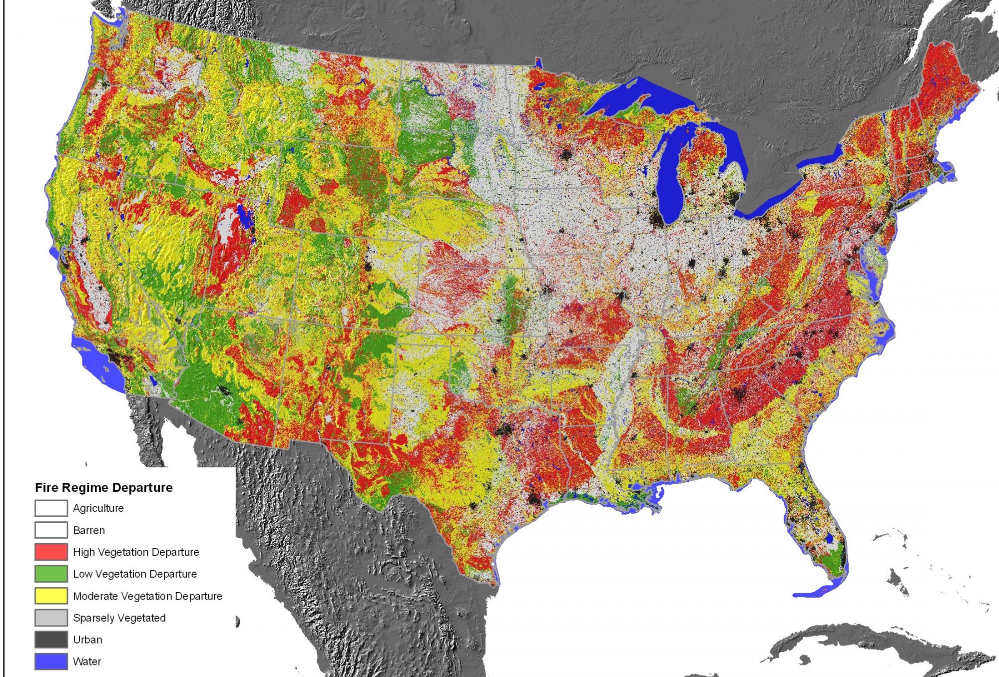
The NatureServe terrestrial ecological systems classification, US National Vegetation Classification, and NatureServe staff expertise on vegetation, form the foundation for this effort. The vegetation types from these classifications are the assessment units for LANDFIRE. A national network of experts developed a series of conceptual “state-and-transition” models to describe succession and disturbance dynamics for each ecological system type. LANDFIRE then produces nationally standardized maps of vegetation type, vegetation structure, and wildfire fuel conditions. LANDFIRE also maintains data sets on current conditions, described in terms of “fire regime departure.” Departure is expressed by vegetation structural stages and their relative proportions in a given area. Alterations to expected fire regime (e.g., frequency, return interval, intensity), often resulting from land use practices over decades, results in measureable differences in vegetation successional and structural stages (e.g., tree density increasing with decades of wildfire suppression), and signaling “departure.” Highly departed conditions correlate with increasing risk of catastrophic wildfire and a loss of quality habitat conditions for biodiversity.
LANDFIRE created and currently updates 30-meter raster data describing current location of vegetation types, major disturbances, and fire/fuel characteristics for the United States. It is the primary national map program providing moderate-to-high resolution geospatial products to support natural resource management and fire/fuel planning.
The most recent version, incorporates vegetation and land cover classes as of 2016-2018. Download updated national map products fro ecological systems, NVC Groups and land use/land cover here.
See our Ecological Systems of the United States page to learn about the Ecological Systems classification. See the US National Vegetation Classification page to learn about the US NVC. See NatueServe Explorere for descriptions of types from both classifications found in LANDFIRE maps.
Additional LANDFIRE data are also available including:
- Biophysical Settting - the natural location of ecological system types had there been no land convsersion
- Fire-related disturbance perimeters
- Geo-referenced vegetation samples, lableed to standard classifications (terrestrial ecological systems and US NVC Groups)
- Historical fire regime and current fire-related conditions
- Surface and vegetation canopy fuels
The multi-agency LANDFIRE effort maintains a series of national data sets in the United States related to wildland fire. These data are used in natural resource assessment, planning, management and monitoring. LANDFIRE data are used in natural resource assessment, planning, management and monitoring. Prior to LANDFIRE, efforts to support decisions for managing wildland fire were made locally. That meant that most decisions were tactical; i.e., how best to fight a wildfire. Strategic approaches to managing wildland fire proactively target resources towards land use and vegetation management that will minimize uncontrollable wildland fire.
Funded under with the National Fire Plan, LANDFIRE was established to make coordinated investments in information, most efficiently developed at the national scale, to ensure that better information was available to state and local jurisdictions to support strategic management decisions.
The NatureServe terrestrial ecological systems classification and staff expertise on vegetation form one foundation for this effort. The vegetation types from these classifications for use as the assessment units for LANDFIRE. Our goal is to provide the ecological assessment units that support the LANDFIRE effort.
By providing reliable information on the location and conditions of vegetation and wildland fire conditions, planners and managers can make better strategic decisions for vegetation management in order to minimize risk of catastrophic losses to life and property, while enhancing the ecological integrity of terrestrial ecosystems.