A collaborative effort to identify the places most important for conserving at-risk species.
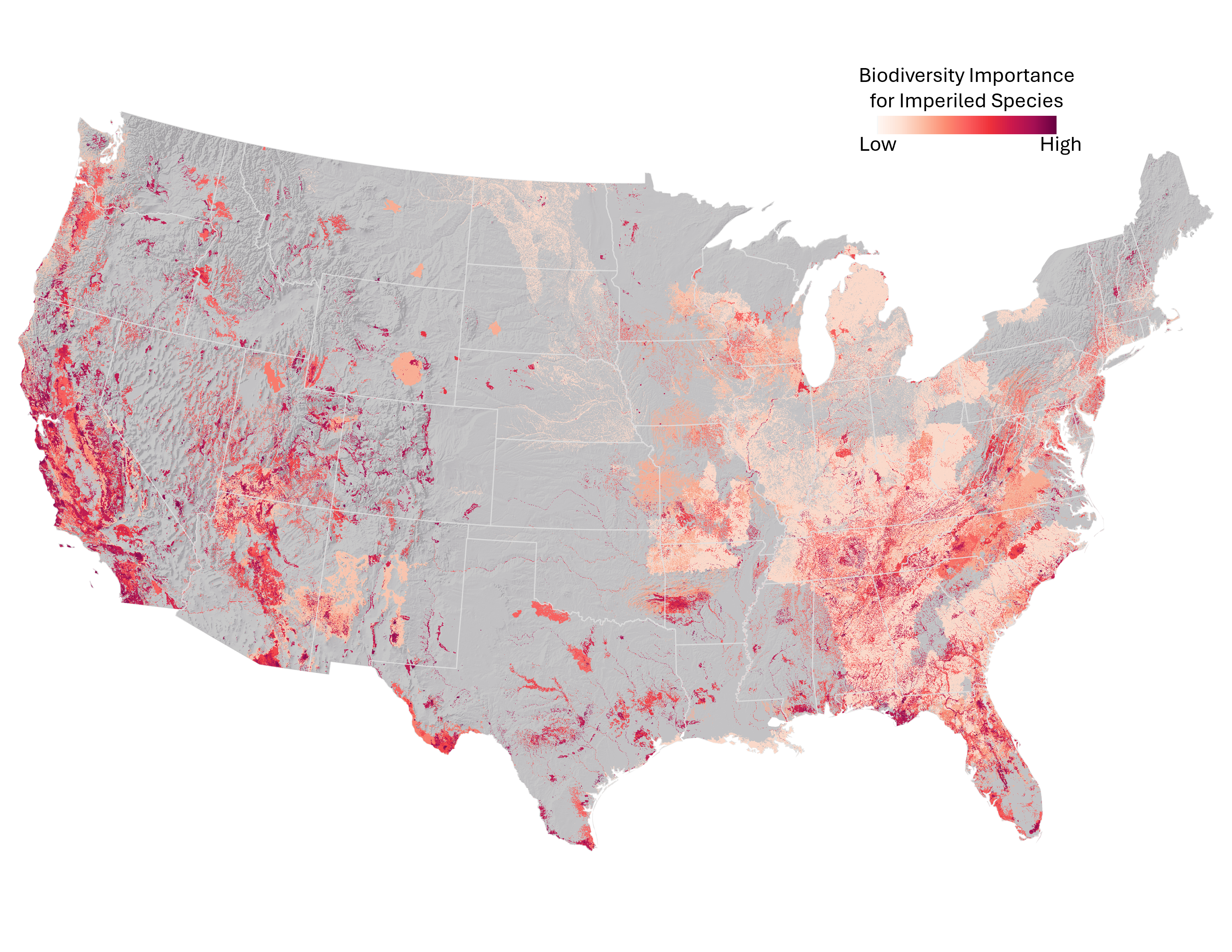
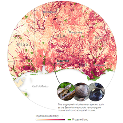
The Map of Biodiversity Importance provides a portfolio of maps that identify areas critical to sustaining our nation's rich biodiversity. Through a landmark collaboration with Esri, The Nature Conservancy, and Microsoft's AI for Earth program, NatureServe and our network of natural heritage programs created a comprehensive set of habitat models for over 2,000 at-risk species in the contiguous United States. We analyzed these models in conjunction with protected areas boundaries to map areas of high importance for conserving vertebrates, freshwater invertebrates, pollinators, and plants. These publicly available products provide an invaluable input to guide effective conservation decision-making.
New in 2024, the Map of Biodiversity Importance has been updated to reflect our current understanding of imperiled species. The Map of Biodiversity Importance 2.0 includes over 500 additional species, including a new group of pollinating insects (solitary bees) and hundreds of species newly identified as imperiled or critically imperiled or listed under the endangered species act. The Map of Biodiversity Importance products are also now at higher resolution: 9X more precise than the original maps.
Keep scrolling down this page to learn more. To explore the data and layers available, see the Living Atlas. For more information, contact us at info@natureserve.org
Read about it in the New York Times
This Map Shows Where Biodiversity Is Most at Risk in America
MARCH 3, 2022
Project Highlights
- From start to finish, the mapping was informed by the authoritative data and deep local knowledge of the NatureServe Network, the nation’s leading source of data and expertise for at-risk species.
- Products include data for a taxonomically and ecologically diverse set of species, including vascular plants, aquatic invertebrates, and pollinating insects—as well as vertebrates.
- Detailed habitat maps for each species were built using state-of-the-art machine learning and cloud computing resources from Microsoft's AI for Earth program.
- Comprehensive, standardized metadata support transparency and model evaluation.
- A national library of over 300 high-resolution environmental data layers and a collaborative online model review tool will support continuous refinement of species habitat maps into the future.
- New insight on the implications of taxonomic diversity and spatial resolution for conservation priority setting.
Major Outputs
- Unparalleled maps identifying areas of biodiversity importance critical to preventing extinctions in the contiguous United States
- Habitat models for over 2,400 at-risk species that NatureServe can adapt to support a wide range of management needs
Project Partners
Network Programs Involved


With additional project support from the NatureServe Network and the William and Flora Hewlett Foundation.