The Coastal and Marine Ecological Classification Standard (CMECS) provides a comprehensive framework for organizing information about coasts and oceans and their living systems. This information includes the physical, biological, and chemical data that are collectively used to define coastal and marine ecosystems.
The standard was designed to meet the needs of many users including resource managers and planners, conservation practitioners, engineers, mappers, and researchers from government, industry and academia that need to describe, map, or assess coastal and marine ecosystems.
CMECS is the result of an ongoing collaboration among several organizations including NatureServe, the National Oceanic and Atmospheric Administration, the U.S. Environmental Protection Agency, the U.S. Geological Survey and the University of Rhode Island.
Note: NatureServe no longer curates CMECS content. Please visit the NOAA National Centers for Environmental Information's CMECS website for information about the CMECS vocabulary and maintenance.
CMECS offers a common terminology for describing natural and human influenced ecosystems from the upper tidal reaches of estuaries to the deepest portions of the ocean. Those using CMECS to can be assured that they are speaking the same language and producing comparable results.
CMECS can be used to support a number of applications at scales from local to global including:
- Ecosystem inventory and mapping
- Coastal and marine spatial planning
- Marine Protected Area selection, evaluation, and assessment
- Resource management and monitoring
- Conservation status assessment
- Habitat modeling
- Ecosystem services evaluation
CMECS has been approved as a federal standard by the Federal Geographic Data Committee (FGDC).
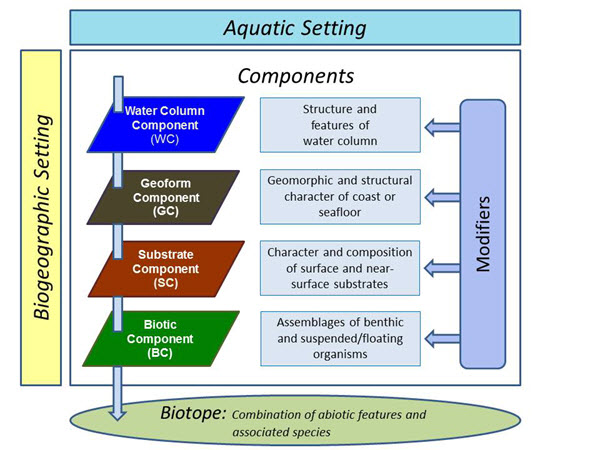
The CMECS framework is organized into two settings, biogeographic and aquatic, and four components, water column, geoform, substrate, and biotic. Each describes a separate aspect of the environment and biota. Settings and components can be used in combination or independently to describe or map ecosystem features. The hierarchical arrangement of units of the settings and components allows users to apply CMECS to the scale and specificity that best suits their interests. Modifiers allow users to customize the classification to meet specific needs. Biotopes can be described when there is a need for more detailed information on the biota and their environment.
CMECS offers many benefits. It is built on existing classification approaches and offers continuity with relevant FGDC wetland and terrestrial standards. It accommodates biological, geological, chemical, and physical data in a single structure. It is applicable to multiple scales and sensors, and facilitates data sharing and integration.
CMECS was developed with input from more than one hundred scientists and coastal managers. A rigorous four month public and peer review process led to consideration and response to more than 800 individual comments from 31 individuals and organizations. The use and application of the standard will improve our knowledge of marine ecosystems and may bring to light other necessary additions and adjustments to the standard. Users will be encouraged to provide suggestions about possible changes to CMECS, which will follow a regular peer review and revision cycle.