Ecological condition commonly refers to the state of the physical, chemical, and biological characteristics of natural ecosystems, and their interacting processes. Many human land uses affect ecological condition, through vegetation removal or alteration, stream diversion or altered natural hydrology, introduction of non-native and invasive species, and others. Landscape condition assessments apply principles of landscape ecology with mapped information to characterize ecological condition for a given area.Since human land uses - such as built infrastructure for transportation or urban/industry, and land cover such as for agriculture or other vegetation alteration – are increasingly available in mapped form, they can be used to spatially model inferences about ecological condition.
Biodiversity conservation demands approaches to inventory, assessment, and monitoring that span a range of spatial scales; from continental to regional landscapes to local sites. At continental scales, we document trends in habitat extent and ecological condition in order to measure progress of regulatory regimes and inform national conservation investments. Conservation planners working in regional landscapes use information on the type and condition of ecosystems and habitats to prioritize sites for protection, contribute to habitat goals, and direct development to minimize conflict. At local scales, decisions regarding preservation or restoration require detailed information on particular site conditions. All require knowledge of the ecological condition. Our task is to ensure that the right information is available across these scales to support good decisions.
When we classify, describe, and map ecosystems and habitats, we state assumptions about ecosystem composition, structure and functions, and its response to human stressors. Ecological condition assessments apply a set of cost-effective indicators of “very high” to “very low” ecological condition. When choosing indicators, preference is given to those that can directly measure change in native species composition in direct response to different levels of stress. However, it is often more feasible to measure a stressor indicator. For example, evidence of hydrologic alteration, or relative naturalness of the buffer, may be relied upon to infer change in native species composition.
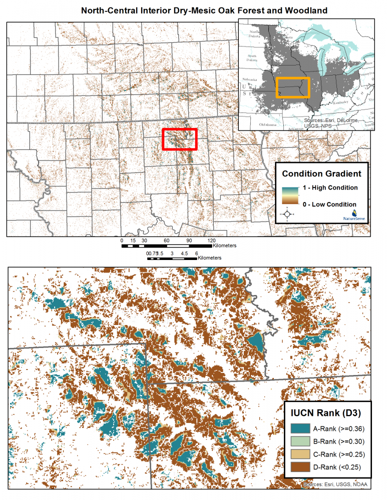
Increasingly a multi-leveled structure is used to assess ecological condition within and across multiple sites. Under NatureServe’s framework, Level 1 (Remote Assessment) relies primarily on remote sensing and indicators of landscape condition affecting ecosystem types. Map inputs include land cover or land use. Level 2 (Rapid Assessment) involves relatively simple indicators easily observed in the field; sometimes in the form of checklists. Indicators may address both stressors (e.g., ditching, road crossings, and pollutant inputs) and condition (e.g., hydrologic connectivity, relative cover of native plant species). Level 3 (Intensive Assessment) requires detailed field measurements and a statistically rigorous sample design. Intensive sampling is costly, so this level of measurement is limited to a relative few “reference sites.”
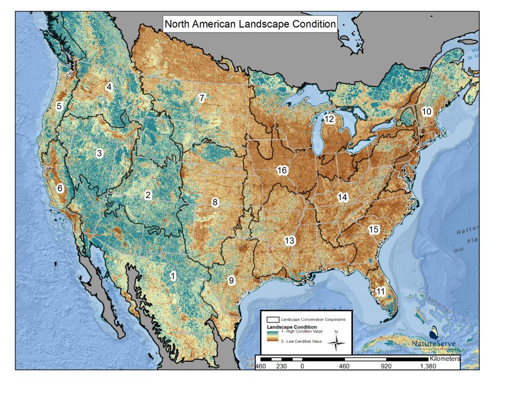
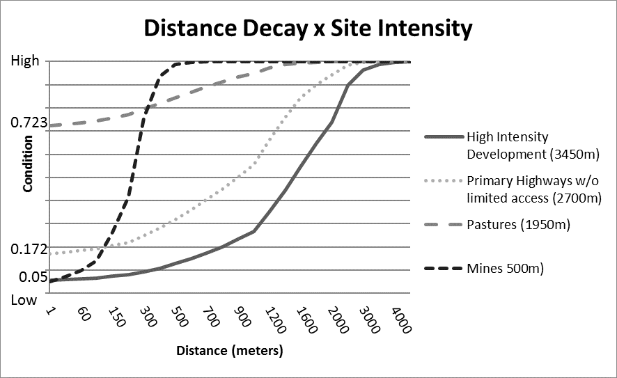
The NatureServe Landscape Condition Model results in a Level 1 index of ecological condition. It builds on the growing body of published methods for spatially-based ecological effects assessment across landscapes. This model applies available spatial data to transparently express user knowledge regarding the relative effects of land uses on natural habitats. Expert knowledge informs stressor selection and weightings, and can integrate insights from the published literature to parameterize the model for application across any given region. This approach to spatial modeling enables users to express assumptions at the site level about the relative ecological effect that each land use type has (called a Site Impact Score) and the potential effect as it diminishes with distance from the site (called a Decay Score). The resulting index combines the scores of all input layers and their per-pixel values. A variety of independent data sets, including fields observations, existing maps, and expert evaluation of high-resolution imagery, are then used to validate the model. This approach is built into NatureServe Vista planning software. One version of the model is used within the Crucial Habitat Assessment Tool developed by partners of the Western Governors Association. A more recent version, covering all of temperate North America, that was both calibrated and validated using field observations from across the continent, is described in a paper in the journal Ecological Indicators.
Hak, J.C. and P.J. Comer. 2017. Modeling Landscape Condition for Biodiversity Assessment – Application in Temperate North America. Ecological Indicators Vol. 82:206-216
This paper may be found at: http://www.sciencedirect.com/science/article/pii/S1470160X17303916
The accompanying maps display this model and the paper summarizes scores regionally. The paper also illustrates applications of the model for establishing rangewide estimates of ecological condition for terrestrial ecosystem types.
Spatial data can be found on the Biodiversity Open Data Hub here.