Identifying At-Risk Species and Ecosystems
NatureServe and our Network assess the conservation status of species and ecosystems to evaluate the risk that a given species will go extinct or a given ecosystem will collapse. For species, we assess full species and subspecific units. For ecosystems, ranking is conducted at multiple levels, from regional to local types (most typically group, alliance, and association, or natural community equivalents). We have developed a rigorous, consistent, and repeatable method for evaluating and documenting the relative imperilment of both species and ecosystems based on the best available science.
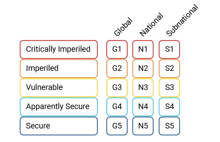
Using a 5-point scale from critically imperiled (1) to secure (5), we evaluate data and published studies to assign conservation status ranks at three geographic scales: global, national, and subnational. We call these Global, National, and Subnational Ranks (or “G-Ranks,” N-Ranks” and “S-Ranks”). You can find the definitions for NatureServe's Conservation Status Ranks on NatureServe Explorer.
Value
Determining which plants, animals and ecosystems are thriving and which are rare or declining is crucial for targeting conservation of the species, and ecosystems in greatest need. Conservation status ranks are widely used throughout the conservation community and are regarded as highly credible by scientists, government agencies and private-sector organizations. These assessments are also a valuable resource for government agencies responsible for administration of Federal, state and provincial species conservation laws.
The purpose of the conservation status ranks developed by NatureServe is to assess the relative risk facing a species or ecosystem and does not suggest that any specific action or legal status is needed to assure its survival. NatureServe is a non-advocacy organization and is committed to providing objective and reliable scientific data.
An example: A species that is widespread throughout North America, but rare at the edge of its range in Florida might have a Global Rank of “G5 – secure globally,” a National Rank of “N5 -secure nationally” in the United States, and a Subnational Rank of “S1-imperiled” in Florida.
Rank Factors
Assessing the conservation status of a plant, animal or ecosystem requires detailed knowledge of its distribution, population size and trends, and critical threats (e.g., habitat loss or fragmentation).
NatureServe and our Network collaborators use eight factors (listed below) to assess the conservation status (extinction risk) of species and ecosystems. We gather information from the literature and field data on each of the factors and then assign a controlled value score to each factor.
Rarity
- Range Extent – the continuous boundary that encompasses all occurrences of a species
- Area of Occupancy – the area within the range extent that is occupied by a species
- Population Size – estimated total number of individuals of the species
- Number of Occurrences – the number of on the ground locations where the species is found
- Number of Occurrences with “Good” Viability – as above but only counting those sites with favorable conditions for the species
- Environmental specificity (used as proxy if none of the above are known) – degree to which the species depends on scarce or highly specific environmental conditions
Trends
- Long Term Trend – trend in any of the rarity factors over the last 200 years
- Short Term Trend – trend in any of the rarity factors over the last 10 years or 3 generations
Threats
- Threats (severity, scope, impact and timing) - Degree of known or inferred direct or indirect threats
- Intrinsic Vulnerability (used as proxy if the threats not known) – characteristics of the species that make it vulnerable or resilient to anthropogenic stresses or catastrophes.
Methods
NatureServe’s methods, which have been evolving since 1978, are used by its network of Natural Heritage Programs and Conservation Data Centres throughout North America. In recent years, NatureServe has worked with IUCN to standardize the ratings for shared information fields, such as Range Extent, Area of Occupancy, Population Size, and Threats. This standardization permits the sharing of information among organizations and countries and allows the information to be used in both IUCN as well as NatureServe assessments.
We use a tool called the “Rank Calculator” to objectively, transparently, and repeatably assign conservation status ranks. The calculator weighs scores by risk category (rarity, trend, threats) resulting in an overall calculated rank, using the 5-point scale from critically imperiled (1) to secure (5). The final conservation status rank is assigned by an expert who reviews the calculated rank.
The Rank Calculator:
- Applies conditional rules for use of factors to ensure that adequate information is used for assessing status.
- Scales and weights factors according to their impact on risk,
- Uses a point system to effectively score the contribution of each factor to risk,
- Weights and combines scores by category resulting in an overall calculated rank,
- Requires that the calculated rank is reviewed by an expert
- Allows for manual adjustment by an expert, within stringent guidelines, if the calculated rank does not account for known ecological or data-related factors
Learn More
Additional Resources
- Assessing Threats and Setting Priorities for Conservation
- The State of Biodiversity Information in Canada
- Threatened Amphibians of the World
- Rivers of Life: Critical Watersheds for Protecting Freshwater Biodiversity
- Geographic Patterns of At-Risk Species
Contacts
- Don Faber-Langendoen
NatureServe
Senior Ecologist/Conservation Methods Coordinator
don_faber-langendoen@natureserve.org
(703) 908-1816 - Kristin Snow
NatureServe
Ecology Database Analyst
kristin_snow@natureserve.org
(703) 908-1815 - Margaret Ormes
NatureServe
Director of Science Information Resources
margaret_ormes@natureserve.org
(617) 287-7183